Pic album: Chitravathi river and check dam full of water in Puttaparthi
Past few days I was too busy to have a look at Chitravathi river myself, and so shared pics of it that others had put up. Yesterday (13th Oct. 2019) I went to Chitravathi river side in the afternoon and took some pics.
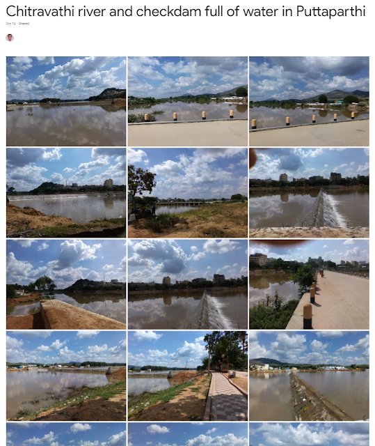
Here's the public Google Photos album titled "Chitravathi river and check dam full of water in Puttaparthi": https://photos.app.goo.gl/WZfw2hQzQJy7kxkM6. Given below is a pic of the album.
[To open pic in larger resolution, right-click on pic followed by open link (NOT image) in new tab/window. In new tab/window you may have to click on pic to zoom in.]
First I went to the bridge to Karnatakanagapalli and took some pics of Chitravathi river from it. One set of pics was towards Kalpavriksha hill/Yenumulapalli village which showed the check dam (small dam) in Chitravathi river. The other set of pics was towards Bukkapatnam.
Then I went to Karnatakanagapalli side of the check dam & took some pics directly from over the check dam clearly showing water overflowing the check dam on that side (but not on the side of check dam towards Puttaparthi). I also took pics from that location of view towards Yenumulapalli village/Kalpavriksha hill, and of view towards Bukkapatnam.
I was told that two days ago when there was lot of water flow in Chitravathi river, water was overflowing across the entire length of the check dam.
I was also informed that at around the same time (or earlier perhaps), as water started collecting at this check dam point, there was a gap on this (Karnatakanagapalli) side of the river bank, from which the water was going out to fields beyond it (or something like that). I was told that the Puttaparthi MLA (Member of Legislative Assembly of Andhra Pradesh which is roughly equivalent to state level (NOT federal level) Congressman in a USA state), Shri D. Sreedhar Reddy, was there at the site early morning that day (11th Oct. I think), perhaps ordering and supervising the work of filling those gaps with mud using (JCB) earthmovers. [I understand that the earthmover vehicles/machines used in and around Puttaparthi are typically from the JCB company, https://www.jcb.com/en-in, and so are known among locals as JCB (vehicles/machines) rather than as earthmovers.] That seems to have resolved the water leakage from the check dam problem.
If the above is true (and I believe it is true) then Puttaparthi residents (including me) should be thankful to our MLA Mr. D. Sreedhar Reddy (I certainly am thankful). The check dam (without leaks) brings Chitravathi river to life as a water body in Puttaparthi (though not as a large flowing water body and more perhaps as a pond that may dry up in summer). That increases the beauty of the place and also increases the sanctity as Bhagavan Sri Sathya Sai Baba has spent many years having satsangs, bhajans and performing miracles on the Chitravathi river banks in past decades. Further, from a water resource point of view, this water body storage enabled by the check dam, should replenish water table in and around it, bringing more water to bore wells of the municipality and of apartment buildings in the area. So the Puttaparthi mandal (county) MLA seems to have done very good service to Puttaparthi residents by his prompt action to plug the water leak from one side of the river bank near the check dam. [Note that Puttaparthi mandal (county) includes many villages and towns in this area besides Puttaparthi town.]
Then I went back to the bridge & took some more pics of the bridge and view from it.
After that I was on Puttaparthi side of Chitravathi river and along the walkway. I took pics from right over the check dam but now from Puttaparthi side of the check dam. I took pics of view towards Bukkapatnam from that point.
I took pics of view of other side of Chitravathi river from this point as I walked further down the walkway, and also of the walkway and view towards Kalpavriksha hill.
I reached the Chitravathi Harathi Point platform and took pics of it and the view of Chitravathi river and beyond from it.
Next to the Chitravathi Harathi Point platform is the Chitravathi Harathi Ghat (steps leading down to the river). I took a few pics of that and the view from there.
I ended the pic taking spree by taking some pics of the view from the walkway from Chitravathi Harathi Ghat towards Yenumulapalli.
I should also say that I think this is the first time after the check dam was built that we have water in Chitravathi river at Puttaparthi. The check dam ensures that this water does not entirely flow down to Bukkapatnam tank (cheruvu) downstream. Only after some amount of water gets collected here, the excess water flows down the check dam towards Bukkapatnam cheruvu.
So I think it is the first time that Chitravathi Harathi Ghat (steps leading to water body) looks like a proper Ghat (even if the water body is more like a pond rather than a flowing river like the Ganga river ghats at Varanasi, https://en.wikipedia.org/wiki/Ghats_in_Varanasi). Hopefully this water body will retain this water for at least 5 to 6 months (till March or April).
This check dam enabled water body also greatly enhances the view from the Chitravathi Harathi Point platform.
All in all, this is good and happy news from Puttaparthi.
[Associated Facebook post: https://www.facebook.com/ravi.s.iyer.7/posts/2619979064885321]
Here's the public Google Photos album titled "Chitravathi river and check dam full of water in Puttaparthi": https://photos.app.goo.gl/WZfw2hQzQJy7kxkM6. Given below is a pic of the album.
[To open pic in larger resolution, right-click on pic followed by open link (NOT image) in new tab/window. In new tab/window you may have to click on pic to zoom in.]

First I went to the bridge to Karnatakanagapalli and took some pics of Chitravathi river from it. One set of pics was towards Kalpavriksha hill/Yenumulapalli village which showed the check dam (small dam) in Chitravathi river. The other set of pics was towards Bukkapatnam.
Then I went to Karnatakanagapalli side of the check dam & took some pics directly from over the check dam clearly showing water overflowing the check dam on that side (but not on the side of check dam towards Puttaparthi). I also took pics from that location of view towards Yenumulapalli village/Kalpavriksha hill, and of view towards Bukkapatnam.
I was told that two days ago when there was lot of water flow in Chitravathi river, water was overflowing across the entire length of the check dam.
I was also informed that at around the same time (or earlier perhaps), as water started collecting at this check dam point, there was a gap on this (Karnatakanagapalli) side of the river bank, from which the water was going out to fields beyond it (or something like that). I was told that the Puttaparthi MLA (Member of Legislative Assembly of Andhra Pradesh which is roughly equivalent to state level (NOT federal level) Congressman in a USA state), Shri D. Sreedhar Reddy, was there at the site early morning that day (11th Oct. I think), perhaps ordering and supervising the work of filling those gaps with mud using (JCB) earthmovers. [I understand that the earthmover vehicles/machines used in and around Puttaparthi are typically from the JCB company, https://www.jcb.com/en-in, and so are known among locals as JCB (vehicles/machines) rather than as earthmovers.] That seems to have resolved the water leakage from the check dam problem.
If the above is true (and I believe it is true) then Puttaparthi residents (including me) should be thankful to our MLA Mr. D. Sreedhar Reddy (I certainly am thankful). The check dam (without leaks) brings Chitravathi river to life as a water body in Puttaparthi (though not as a large flowing water body and more perhaps as a pond that may dry up in summer). That increases the beauty of the place and also increases the sanctity as Bhagavan Sri Sathya Sai Baba has spent many years having satsangs, bhajans and performing miracles on the Chitravathi river banks in past decades. Further, from a water resource point of view, this water body storage enabled by the check dam, should replenish water table in and around it, bringing more water to bore wells of the municipality and of apartment buildings in the area. So the Puttaparthi mandal (county) MLA seems to have done very good service to Puttaparthi residents by his prompt action to plug the water leak from one side of the river bank near the check dam. [Note that Puttaparthi mandal (county) includes many villages and towns in this area besides Puttaparthi town.]
Then I went back to the bridge & took some more pics of the bridge and view from it.
After that I was on Puttaparthi side of Chitravathi river and along the walkway. I took pics from right over the check dam but now from Puttaparthi side of the check dam. I took pics of view towards Bukkapatnam from that point.
I took pics of view of other side of Chitravathi river from this point as I walked further down the walkway, and also of the walkway and view towards Kalpavriksha hill.
I reached the Chitravathi Harathi Point platform and took pics of it and the view of Chitravathi river and beyond from it.
Next to the Chitravathi Harathi Point platform is the Chitravathi Harathi Ghat (steps leading down to the river). I took a few pics of that and the view from there.
I ended the pic taking spree by taking some pics of the view from the walkway from Chitravathi Harathi Ghat towards Yenumulapalli.
I should also say that I think this is the first time after the check dam was built that we have water in Chitravathi river at Puttaparthi. The check dam ensures that this water does not entirely flow down to Bukkapatnam tank (cheruvu) downstream. Only after some amount of water gets collected here, the excess water flows down the check dam towards Bukkapatnam cheruvu.
So I think it is the first time that Chitravathi Harathi Ghat (steps leading to water body) looks like a proper Ghat (even if the water body is more like a pond rather than a flowing river like the Ganga river ghats at Varanasi, https://en.wikipedia.org/wiki/Ghats_in_Varanasi). Hopefully this water body will retain this water for at least 5 to 6 months (till March or April).
This check dam enabled water body also greatly enhances the view from the Chitravathi Harathi Point platform.
All in all, this is good and happy news from Puttaparthi.
[Associated Facebook post: https://www.facebook.com/ravi.s.iyer.7/posts/2619979064885321]
Comments
Post a Comment